As societies look to decarbonize and reconfigure their infrastructure for a more sustainable future, new technologies continue to emerge with promises of efficiency, speed, and optimization. Drones are one such technology which is often presented as agile tools for logistics, monitoring, and emergency response. As any other technology, their impact on sustainability is dependent on the systems we build around them. One of the most important developments from European Union Aviation Safety Agency (EASA) enabling drones to operate safely and at scale is U-space- a framework designed to manage drone traffic in shared airspace. As this digital infrastructure takes shape, it raises broader questions about the kind of drone ecosystem we want to create, and how it can align with the values of sustainability, resilience, and public interest.
What is U-space?
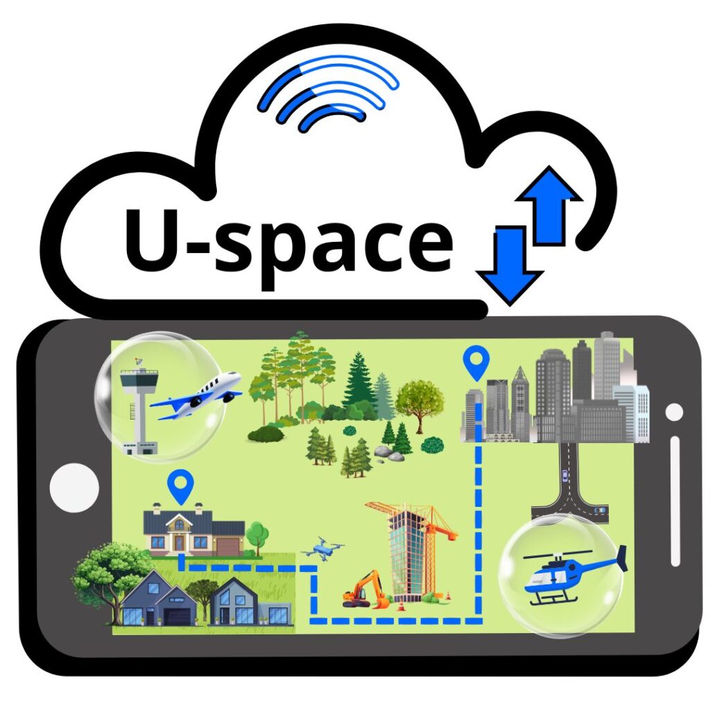
U-space refers to a set of services and protocols—now regulated under EU Regulation 2021/664—that enable safe and efficient drone operations in low-altitude airspace. It acts as a digital traffic management system for unmanned aircraft, allowing multiple operators to access shared airspace without compromising safety, privacy, and coordination with other users. EASA has established this approach with 5 core U-space services, namely
- Network Identification
- Geo-awareness
- Flight Authorization
- Traffic information
- Strategic deconfliction
At a technical level, U-space is designed to coordinate flights, manage real-time information, and reduce risks of conflict between drones and other airspace users. But on a broader level, it reflects an evolving approach to governing the commons—in this case, the airspace just above our living spaces, critical infrastructures, and green areas. An outlook beyond just U-space enabling more drones is that it shapes how they interact with the world, and who benefits from their presence. It entails a distributed ecosystem of actors and services, each contributing to enabling scalable, safe, and predictable drone operations.
The Architecture of the U-Space system
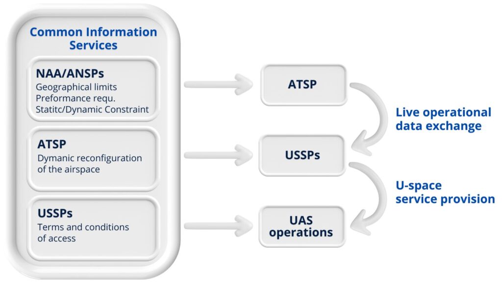
Within this structure, two types of services play central roles: U-space services and Common Information Services (CIS). U-space services are delivered by certified private entities known as U-space Service Providers (USSPs). These services include real-time drone identification, geo-awareness to keep drones informed about local airspace rules, automated flight authorization, and conflict detection tools that help prevent mid-air incidents. These digital tools allow operators to safely plan and execute flights in even the most complex environments, including those shared with manned aircraft.
Complementing this are the Common Information Service Provider (CISP), which provide the foundational data that all stakeholders such as the USSPs, ANSPs and UAS operators rely on. This includes real-time updates about airspace restrictions, weather conditions, temporary hazards, and data from manned aviation. European Member States may designate a single CISP for their U-space airspace or allow multiple providers, depending on their national implementation strategy. The goal is to ensure that everyone using U-space services has access to the same, consistent information, reducing the chance of miscommunication or gaps in coverage.
U-space is an information layer built on top of existing regulatory airspace classifications, such as those already defined nationally and locally (e.g., Class G, C, D). National and local authorities remain responsible for defining U-space volumes within their jurisdiction and ensuring the deployment of U-space aligns with their safety, mobility, and environmental policy objectives.
At the operational level, drone operators and pilots interface with the U-space ecosystem through U-space Service Provider (USSP) also known as (UAS Traffic Management) UTM platforms, which deliver key services such as flight authorizations, situational updates, and compliance support—integrating seamlessly with the established airspace structure.
U-space also distinguishes between controlled and uncontrolled airspace. In controlled areas, traditional air traffic controllers remain responsible for managing the separation of manned aircraft and drones. However, in uncontrolled airspace, U-space services play a more prominent role in coordinating movements, especially through the use of surveillance technologies and digital communication between drones and manned aircraft such as helicopters. Regardless of airspace type, communication, data availability, and situational awareness remain critical components of safe operations.
Central to the effectiveness of U-space is the availability and synchronization of information. The ecosystem is designed to ensure that all actors are working from the same set of real-time data, including airspace restrictions, current weather, authorized drone operations, and notifications from aviation authorities. These data flows are managed through secure digital networks, enabling high levels of automation and reliability in how drone flights are coordinated.
Pilot deployments and designated U-space areas are currently being established in several EU countries, where early lessons are helping shape interoperability standards, data sharing protocols, and operational procedures. These first implementations are key to determining how scalable and adaptable the system is in practice.
Integrating sustainability thinking
As drones become more visible in public discourse, their use is often linked to sustainability goals: reducing last-mile delivery emissions, enabling precision agriculture, supporting disaster response, or monitoring biodiversity. However, whether drones contribute to sustainability or simply replicate existing inefficiencies in a new format, depends on how they are deployed, who controls their use, how their supporting infrastructure is designed, as well as who owns the artefacts and responsibilities. U-space, as the foundational framework for drone operations in Europe, will have a large influence on this trajectory.
The provision of U-space services can determine:
- whether airspace remains accessible to public-interest missions, such as environmental monitoring or medical logistics
- how noise, privacy, and visual impacts are managed in urban environments
- inclusion of energy efficiency can be included as one of the primary parameters for drone operations through route optimization and coordinated traffic flow
- the integration (or fragmentation) of drone services with public infrastructure and mobility systems
- ensuring that mechanisms remain open to be adaptive and reflect more than just operational efficiency—consider equity, transparency, and long-term impact.
New actors that will be USSP providers can cease this opportunity in its formative stages. Such decisions around system architecture, data governance, business models, and public engagement will influence integration of drones in ways that support sustainability goals.
Thus, U-space is more than a technical framework for drone traffic management—it is a blueprint for how we integrate emerging technologies into our daily lives, economies, and infrastructure. As low-altitude airspace becomes a vital layer of mobility and logistics, the choices we make today will shape a sector from the ground up, with value creation rooted in innovation, efficiency, public trust, and energy goals for systems transition.

This article is written by Aishwarya Raghunatha, an Industrial PhD student and expert in drone transport planning and sustainability.
Aishwarya (Aisha) is an industrial PhD student in Advanced Air Mobility and is therefore one of Aero EDIH’s resources. Aishwarya Raghunatha is affiliated with the Future-Proof Cities research program at the University of Gävle.
Her research focuses on Advanced Air Mobility (AAM), exploring how electric-powered or hydrogen-powered delivery drones can contribute to sustainable and environmentally friendly transport systems in urban and rural areas. Specifically, her project examines how sustainability aspects, from the perspective of community inhabitants, energy efficiency, and environmental goals are affected by digital and technological solutions aimed at enhancing resilience in critical infrastructures.