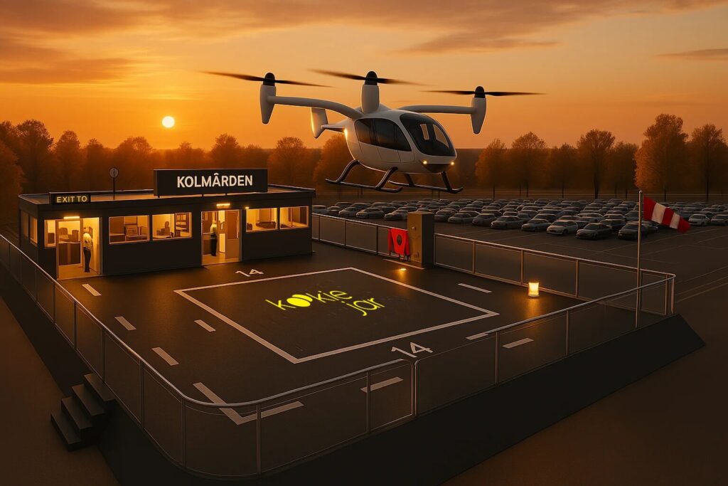
The successful deployment of drone transportation systems is not merely about flight capabilities or airspace regulations; it hinges on the quality and preparedness of the supporting infrastructure. Drones require specialized hubs for take-off, landing, recharging, and maintenance. These so-called “vertiports” and drone corridors are essential for ensuring that operations are efficient, scalable, and safe. These serve as the ground-based hubs for vertical take-off and landing (VTOL) operations. Unlike airports or heliports, vertiports are designed specifically for high-frequency drone or eVTOL activity. These facilities are where aircraft take off, land, recharge, undergo maintenance. Without a robust network of well-located and properly designed vertiports, the promise of scalable and efficient drone mobility cannot be realized.
Technical Blueprint for Safe Vertiports
According to the European Union Aviation Safety Agency (EASA), which released Prototype Technical Design Specifications for Vertiports, these hubs must meet specific structural and operational criteria to ensure safety and interoperability. The design guidelines outline the minimum requirements for essential components such as the Final Approach and Take-Off area (FATO) and the Touchdown and Lift-Off area (TLOF). These areas must be free of obstacles, with appropriate dimensions based on the aircraft size.
In addition, EASA emphasizes the importance of surface quality (for stability during landing), visual aids like lighting and markings, and clearly delineated zones for charging, taxiing, and emergency operations. These specifications form the backbone of vertiport safety and functionality, offering a template for cities and private developers alike. Vertiport networks must be designed for scalability and adaptability, able to accommodate evolving aircraft types, changing traffic volumes, and new technologies like automated traffic management or hydrogen fuel systems. Locations must be chosen with potential for expansion, and regulatory frameworks should remain flexible to support innovation. Integrating green roofs, solar energy systems, multimodal charging stations, etc in these infrastructures will be key in meeting urban sustainability goals.
Strategic Location Planning: Challenges and Considerations
However, designing vertiports to spec is only part of the equation. One of the greatest challenges lies in strategically locating vertiports within urban and regional contexts. Vertiports must contend with three-dimensional airspace constraints, urban density, and public concerns. In dense urban environments, suitable real estate is scarce, and repurposing rooftops or underused spaces can be both technically complex but more sustainable. Key siting factors include accessibility, noise exposure, airspace compatibility, and zoning laws. For example, placing a vertiport near business centres might offer excellent multimodal connectivity, but it could face pushback due to concerns about noise or safety from nearby residents. Urban planners must therefore balance competing interests, often working with aviation authorities to model flight paths and noise impact zones before selecting sites.
Connecting Vertiports with Multimodal Transport Systems
Moreover, integration with existing mobility systems is vital to maximize utility and adoption. Vertiports must not function in isolation, serving only drones or air taxis—they need to be embedded in the larger transportation fabric, ideally interfacing with buses, metros, bike paths, and pedestrian corridors. This enables true multimodality, allowing a parcel or person to seamlessly transition from air to ground transport. Such integration requires coordinated planning between civil aviation authorities, transport agencies, urban designers, and local communities. Without this alignment, drone infrastructure may end up as disconnected tech silos; novel but underutilized, and ultimately inefficient.
Thus, achieving this level of integration demands more than just technical developments; it requires a rethinking of infrastructure as a connective layer within a broader mobility ecosystem. From the structural integrity of landing zones to the socio-spatial decisions of site selection, every element plays a role in developing efficient, scalable, and responsive multimodal drone-based network. When thoughtfully planned and strategically embedded, vertiports can be utilized to support drone transport, as well as overall coherence and inclusivity of urban mobility systems.

Aishwarya Raghunatha – Industrial PhD student, an expert in drone transport planning and sustainability
Aishwarya (Aisha) is an industrial PhD student in Advanced Air Mobility and is therefore one of Aero EDIH’s resources. Aishwarya Raghunatha is affiliated with the Future-Proof Cities research program at the University of Gävle.
Her research focuses on Advanced Air Mobility (AAM), exploring how electric-powered or hydrogen-powered delivery drones can contribute to sustainable and environmentally friendly transport systems in urban and rural areas. Specifically, her project examines how sustainability aspects, from the perspective of community inhabitants, energy efficiency, and environmental goals are affected by digital and technological solutions aimed at enhancing resilience in critical infrastructures.